[1]把shp数据导入到postgres(postgis)
[2]road.map文件内容如下
# Map file generated by QGIS version 0.7.4
# Edit this file to customize for your interface
# Not all sections are complete. See comments for details.
NAME road
STATUS ON
# Map image size. Change size as desired
SIZE 256 256
#
# Start of web interface definition. Only the TEMPLATE parameter
# must be specified to display a map. See Mapserver documentation
#
WEB
# HEADER
# TEMPLATE
# FOOTER
MINSCALE 1
MAXSCALE 8
# Set IMAGEPATH to the path where mapserver should
# write its output
IMAGEPATH 'd:\\tmp\\'
# Set IMAGEURL to the url that points to IMAGEPATH
#IMAGEURL '/map_output/'
END
PROJECTION
"init=epsg:4326"
END
# Extent based on full extent of QGIS view
EXTENT 115.275 39.2204 117.475 40.9462
UNITS METERS
IMAGECOLOR 255 255 255
IMAGETYPE gif
# Projection definition
# Projections are not currenlty supported. If desired, add your own
# projection information based on Mapserver documentation.
#
LAYER
NAME road
TYPE LINE
STATUS ON
CONNECTIONTYPE POSTGIS
CONNECTION "host=localhost dbname=mapdb user=postgres password=postgres port=5432"
DATA "the_geom from beijing_polyline using unique gid using srid=4326" #DATA "d:\\wwwroot\\shp\\Rbeijing.shp"
CLASS
NAME "ROAD"
# TEMPLATE
OUTLINECOLOR 112 238 238
END
END
END # Map File
蓝色的部分就是连接postgis数据库的部分,和取数据的部分
[3]road.html
<html xmlns="http://www.w3.org/1999/xhtml">
<head>
<style type="text/css">
##mapdiv {
width: 800px;
height: 475px;
border: 1px solid black;
}
</style>
<script src="/OpenLayers/OpenLayers.js"></script>
<script type="text/javascript">
//Google has 20 scales
//Resolutions always start big to small, descending order
//numZoomLevels=20 (corresponds to Googles 20 zoom levels)
//map.setCenter(center, 19); (Zoom Level starts at 0 and ends in 19)
window.onload = function() {
map = new OpenLayers.Map('mapdiv');
var serverURL = "/cgi-bin/mapserv";
var layer_obj = new OpenLayers.Layer.WMS(
"road",
serverURL,
{
layers: 'road',
map : 'd:\\wwwroot\\postgis\\road.map', format: 'gif'
},
{
//reproject: false,
'numZoomLevels': 20,
gutter: 15,
buffer: 0
}
);
layer_obj.setIsBaseLayer(true);
layer_obj.setVisibility(true);
map.addLayer(layer_obj);
map.addControl(new OpenLayers.Control.PanZoomBar());
map.addControl(new OpenLayers.Control.MousePosition());
map.addControl(new OpenLayers.Control.LayerSwitcher());
map.addControl(new OpenLayers.Control.Scale());
var center = new OpenLayers.LonLat(116.39166, 39.90625);
map.setCenter(center, 8);
}
</script>
</head>
<body>
<div id="mapdiv"></div>
</body>
</html>
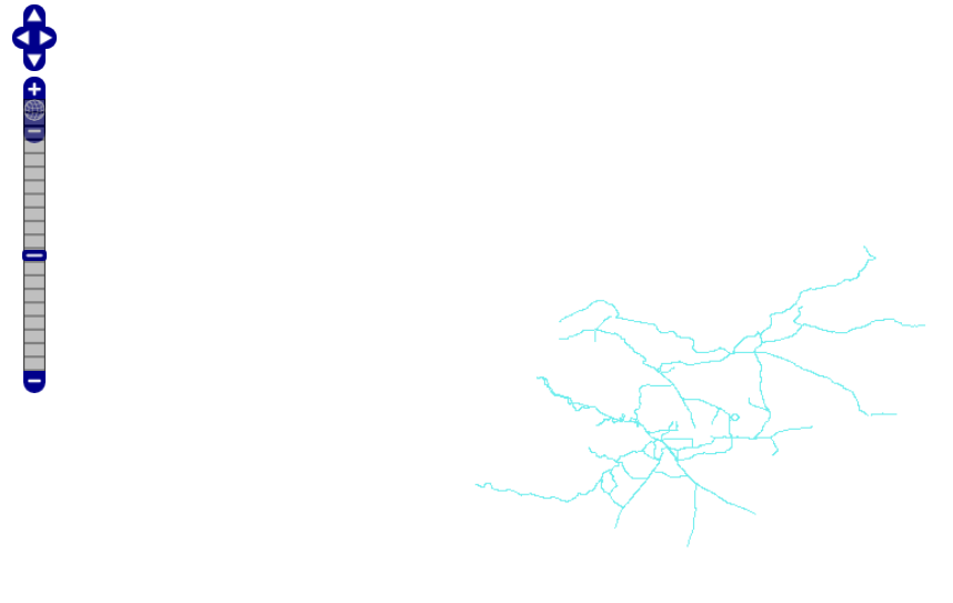
访问http://localhost:8888/postgis/road.html,可以看到地图结果如下:
|----------------------------------------------------------------------------------------|
版权声明 版权所有 @zhyiwww
引用请注明来源 http://www.blogjava.net/zhyiwww
|----------------------------------------------------------------------------------------|
posted on 2009-02-20 18:19
zhyiwww 阅读(2610)
评论(4) 编辑 收藏 所属分类:
gis 、
Postgis